ARE WE THE LAST SURVIVORS? Evidence of submerged civilizations
Updated: 4 hours ago
The areas marked in red in the image represent areas of land in the central Mediterranean that were submerged as the last Ice Age came to an end. This phenomenon isn’t limited to this part of the world: traces of the same process are visible in many regions across the planet, at virtually every latitude. And we’re not talking about millions of years ago. We’re talking about 14,000 years ago—a time surprisingly close to us when compared to the history of the human species.
A Completely Different North America
During the last ice age, enormous amounts of water were trapped in the ice, and sea levels were much lower than they are today: large portions of what are now coastal plains were therefore dry land, while to the north, vast ice sheets covered much of Canada and the northern United States. With the rapid warming that began at the end of the Pleistocene, the ice retreated, sea levels rose by tens of meters, and entire coastal landscapes were gradually submerged—from the Atlantic to the Gulf of Mexico and all the way to the Pacific. Here, too, the geography inhabited by humans changed radically in just a few thousand years: coastlines, plains, and migration routes that once existed are now beneath the sea.

Today’s Oceania did not exist
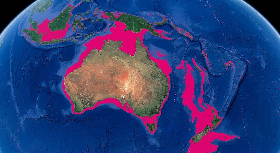
In Oceania, the change was even more evident. During the last ice age, when sea levels were much lower, Australia, New Guinea, and Tasmania were part of a much larger continental landmass—now known as Sahul—while vast coastal plains covered areas that are currently submerged. As the ice melted and sea levels rose, those lands were gradually submerged by water, separating regions that had previously been connected and profoundly transforming coastlines, migration routes, and habitable territories. This means that a significant portion of the landscapes inhabited by the prehistoric peoples of Oceania did not disappear because they were destroyed by the passage of time: they are simply beneath the sea. Vast areas of present-day Indonesia were part of a much larger landmass, now known as Sundaland. In other words, the world back then was not simply a colder version of today’s world. It was geographically different.
A Completely Different Mediterranean
Before the last major ice melt, the Mediterranean landscape was very different from what it is today. Sardinia and Corsica were essentially a single large island, while between Sicily, Malta, and the nearby coasts there were extensive stretches of land that are now submerged. The Adriatic Sea was much smaller, and the Po River flowed through a vast plain, much larger than the one we see today.

Doggerland in Northern Europe
One of the most striking examples is Doggerland, the vast region that, during the last ice age, connected present-day Great Britain to continental Europe. Where the North Sea lies today, there were once plains, rivers, lakes, wetlands, and areas inhabited by human groups for millennia. As sea levels began to rise at the end of the last ice age, this landscape was gradually submerged until it disappeared almost entirely. Today, traces of it remain on the seafloor, along with artifacts, bones, and ancient waterways: concrete evidence that entire inhabited territories can be erased from the visible landscape and survive only beneath the sea.

A World Changing Before Their Eyes
For the people of that era, the melting ice was not merely a climatic event. It meant witnessing the landscape transform rapidly. A bay could become a stretch of open sea. A plain could turn into a marsh, then into a lagoon, and finally disappear beneath the water. An island could become permanently separated from the mainland. Ancient routes used for centuries could become impassable.
People were forced to move, gradually following the new coastlines and abandoning territories where their ancestors had lived for generations. For us, this process is visible only on maps reconstructed by scholars. For those who lived then, however, it was something that was actually happening right before their eyes.
Then Came the Sea
The melting of the great glaciers of Northern Europe and North America released immense quantities of water. The shoreline gradually moved inland, although during certain periods the change was much more rapid.
Territories that for thousands of years had been plains, river valleys, or coastal areas ended up submerged beneath the sea.
And it was precisely the coastlines—then as now—that were among the most favorable places for human settlement: they offered water, fishing, transportation routes, and terrain that was generally easier to traverse.
This is a crucial detail. It wasn’t necessarily marginal, uninhabited land that was submerged. In many cases, some of the areas that might have been most suitable for life were the very ones that disappeared. For the people of that era, all of this must have seemed like a true apocalypse.
The World Has Not Always Been as We See It Today
One of the most common mistakes is to imagine the past through the lens of today’s geography. We look at a modern map and, almost without realizing it, assume that those coastlines, deserts, and natural boundaries have always existed in the same way. But that is not the case.
The thaw that began about 14,000 years ago, the comet bombardment that occurred about 12,800 years ago—now accepted and proven by the scientific community as a whole—the Younger Dryas, a mini ice age that occurred about 11,800 years ago, and finally the desertification of the Sahara that began about 9,000 years ago have completely reshaped the environment in which humans have lived over the past 15,000 years. We observe the world after all these events. But the populations that came before us lived on a different planet.
How Many Traces Have Ended Up Under the Sea?
You don’t need a degree in archaeology to understand a very simple fact. If a city, village, or settlement was located along a coastline that is now submerged, then what remains of it lies beneath the sea. And in many cases, it may also be covered by meters of sediment and mud accumulated over the millennia. If organized communities existed along those ancient coastlines, today we might be looking at the traces of entire submerged civilizations.
This means it is incorrect to claim that we know all the civilizations that have existed in our past. We know mainly those that were fortunate enough to be in the right places. We know the civilizations that were not submerged by rising waters, those that were not wiped out by catastrophic events, and those that were not located in regions like the Sahara before it became a desert.
We Are Merely the Survivors
What we now call the “known past” may be nothing more than the fragment that remains visible after a long series of climatic and environmental changes that have wiped out entire regions. And perhaps the most important point is precisely this: we are the survivors. Others, before us, may simply not have been so fortunate. Will it happen again?
You can learn more about this topic here:


Comments